Physical Regions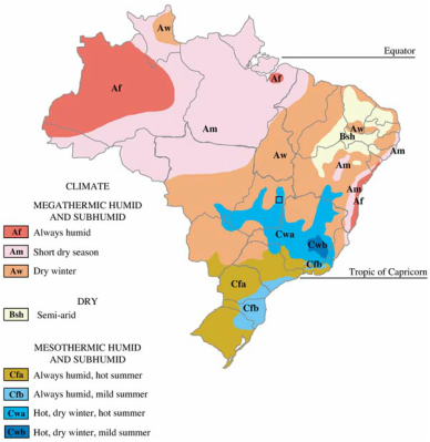
This map shows the climate regions of Brazil. Red, pink, and orange are megathermic humid climate regions. Yellow is dry climate regions. Green and blue are mesothermic humid climate regions. Climates are similar in different regions of Brazil. Northern Brazil has more megathermic humid climates and southern Brazil has more mesothermic humid climates.
Soils and Climate. (2003). Retrieved September 14, 2015, from http://www.fao.org/docrep/007/y5376e/y5376e06.htm 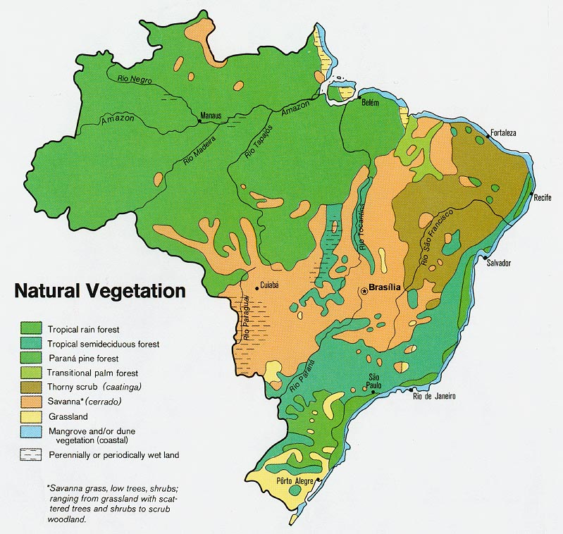
This map shows the natural vegetation of Brazil. Brazil's vegetation forms regions of tropical rain forests, pine forests, palm forests, savannas, grasslands, wetlands, and much more. The largest region in Brazil is a tropical rain forest.
Brazil Natural Vegetation Map. (n.d.). Retrieved September 14, 2015, from http://www.zonu.com/brazil_maps/Brazil_Natural_Vegetation_Map.htm Cultural Region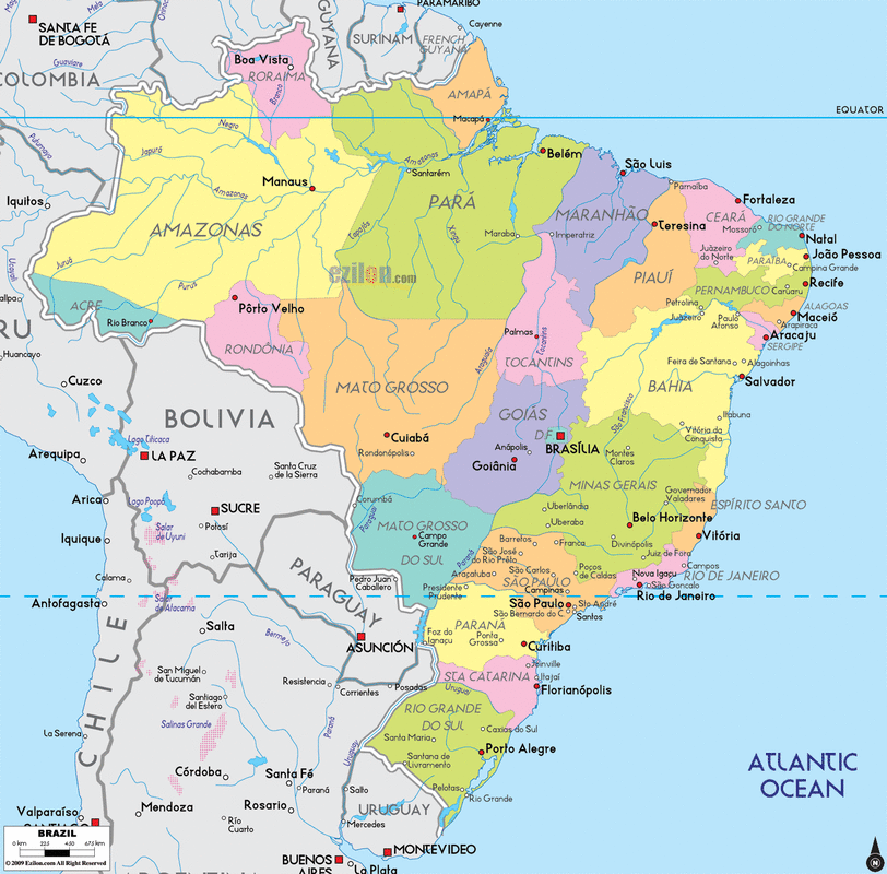
This map shows the political regions of Brazil. The two largest political regions of Brazil are Amazonas and Para. The smallest political regions are near the coast of Brazil.
Brazil Map - Political Map of Brazil. (n.d.). Retrieved September 14, 2015, from http://www.ezilon.com/maps/south-america/brazil-maps.html Human Features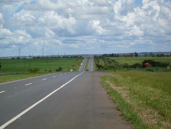
This is an image of BR-050, a major highway in Brazil. It extends north and south from the national capital of Brasilia. Many people travel on this highway to get to Santos city or Sao Paulo.
Portal do Trânsito. (n.d.). Retrieved September 14, 2015, from http://portaldotransito.com.br/noticias/acontecendo-no-transito/pedagio-na-br-050-e-6o-mais-barato-entre-rodovias-federais 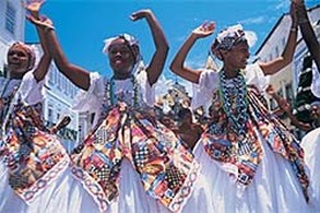
This image is of traditional Brazilian clothing. Brazil is known for its classy and sophisticated clothing. Brazilian clothing is colorful, detail oriented, and comfortable. It represents Brazilian culture and social status.
Traditional Brazilian Clothing. (n.d.). Retrieved September 14, 2015, from http://www.expodude.com/A/?C-1-267.html 
This is an image of Feijoada, a common dish ate by Brazilians. It is a stew made of black beans, sausage, and pork. It takes about twenty four hours to prepare so it is one of Brazil's fine foods.
Top 10 Foods to Try in Brazil. (n.d.). Retrieved September 14, 2015, from http://www.bbcgoodfood.com/howto/guide/top-10-foods-try-brazil 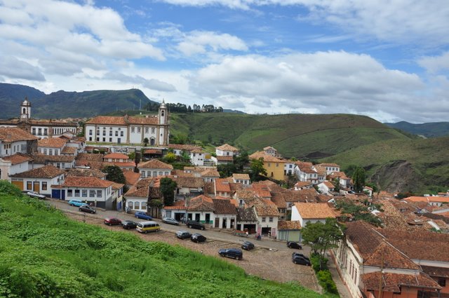
Brazil is a heavily populated country. This image is an example of a typical housing development in Brazil. Humans have changed the natural environment of Brazil by building houses and developing neighborhoods.
Homes in Brazil. (n.d.). Retrieved September 14, 2015, from http://vintage.johnnyjet.com/photos/PicForNewsletter-Ouro-Preto-Brazil-Jan-2009-7.jpg 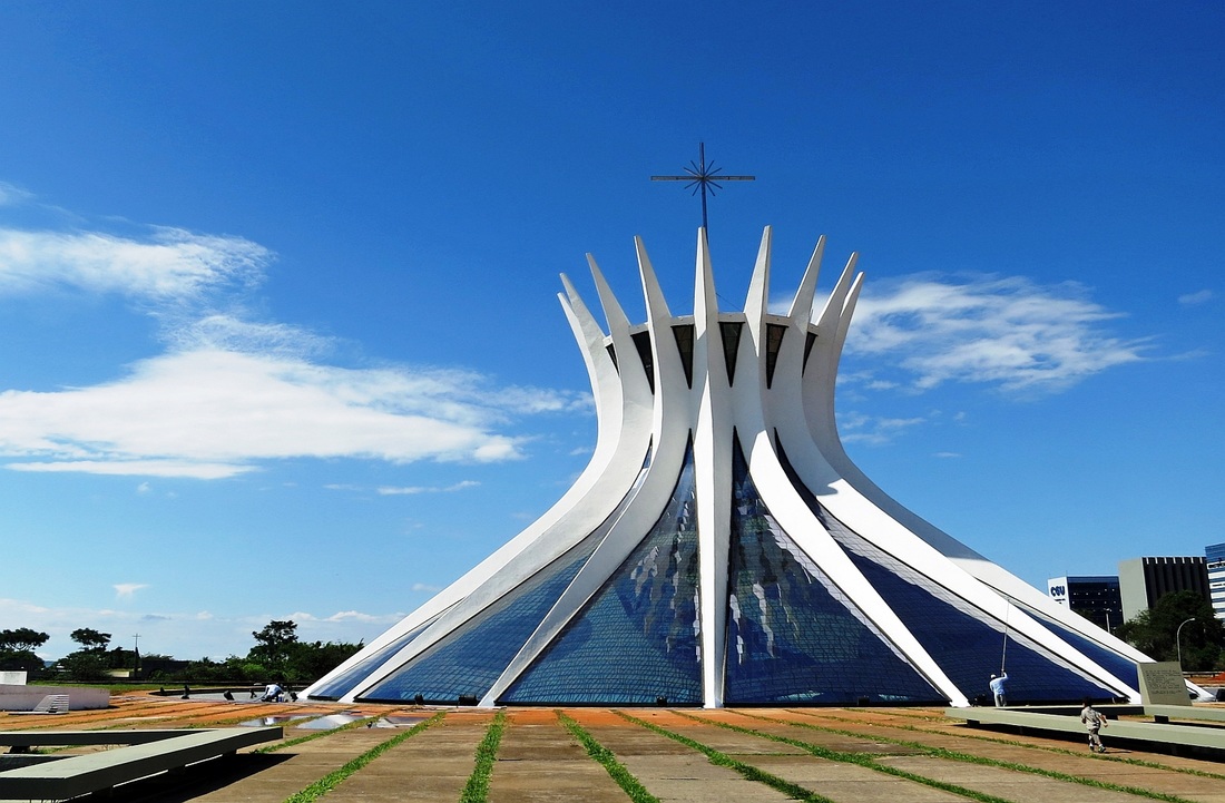
This is an image of the Cathedral of Brasilia. It is a man-made Roman Catholic cathedral in Brazil. It has beautiful architect and serves as a building for religious ceremonies.
Cathedral Of Brasilia. (n.d.). Retrieved September 14, 2015, from http://www.movdata.net/cathedral-of-brasilia.html |
Physical Features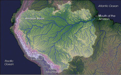
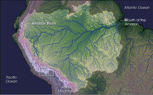
This images shows Brazil's Amazon Basin. The Amazon Basin is a depression in earth's surface that contains water from the Amazon River. The climate near the basin is hot and humid. It is home to a wide variety of plants and animals.
Amazon Basin. (n.d.). Retrieved September 14, 2015, from http://2012books.lardbucket.org/books/regional-geography-of-the-world-globalization-people-and-places/section_09/bb8f48c1aee1d754d39eb44e7c82e35f.jpg 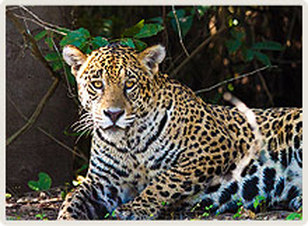
This image is of a jaguar. Jaguars are one of the world's largest cats and they populate in Brazil. They have a leopard spot appearance and vary in darkness. Many of them live in the wetlands where they stock and ambush prey.
Brazil - Just Jaguars (n.d.). Retrieved September 14, 2015, from https://www.naturetrek.co.uk/tour.aspx?id=41 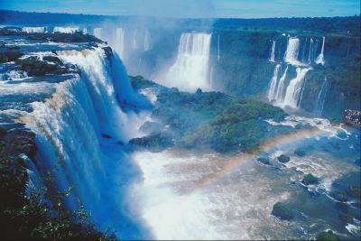
This is an image of Iguacu Falls located between Brazil and Argentina. It is the largest waterfall in South America. This waterfall is a tourist attraction that brings many people to Brazil.
Amazon Basin. (n.d.). Retrieved September 14, 2015, from http://2012books.lardbucket.org/books/regional-geography-of-the-world-globalization-people-and-places/section_09/bb8f48c1aee1d754d39eb44e7c82e35f.jpg 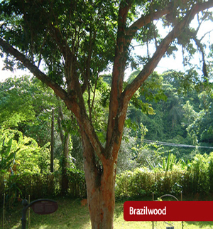
This image is of a Brazilwood tree. Brazil was named after Brazilwood trees because they were abundant and native to Brazil. The wood is used for fine woodwork and the tree produces valuable red dye.
Red. (2013). Retrieved September 14, 2015, from http://www.dharmatrading.com/home/red.html 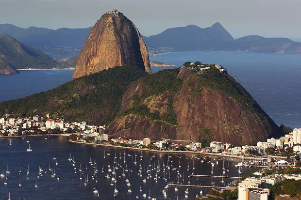
This is an image of Sugarloaf Mountain located in Rio De Janeiro, Brazil. It is known for its dome shape that resembles a sugarloaf. It rises 396 meters above the harbor.
Petty crime, deprivation, no English – is Rio ready? (2013, January 25). Retrieved September 14, 2015, from http://www.thetimes.co.uk/tto/sport/olympics/article3667515.ece |
Biodiversity and Cultural Diversity
|
Brazil is filled with both biodiversity and cultural diversity. Cultural diversity is the existence of many cultures and biodiversity is the variety of life. Brazil is known to be one of the richest biodiversities. Brazil is also one of the seventeen megadiverse countries (“Brazil-Overview”). Not only does Brazil hold a wide variety of life but it is multicultural. Biodiversity and cultural diversity are connected in the country of Brazil.
Before European settlers, indigenous groups populated Brazil. Each of these indigenous groups had their own cultures, traditions, and values. They had their own languages and customs. These indigenous groups learned to live and survive on the environment around them. Many of them were hunters and gathers. They relied on animals and plants as a source of food and plants as resources to build shelter (“Brazilian Indians”). The variety of life allowed for cultural diversity. The cultural diversity in Brazil started to decrease. Land was stolen from indigenous people to create cattle ranches, soy fields, and sugar cane plantations. Industrialization decreased the cultural diversity in Brazil. Industrialization also destroyed the natural habitats of plants and animals decreasing the biodiversity of Brazil. The indigenous people were forced off their land. Many of them had to assimilate into a larger culture and live the way others wanted them to live (“Brazilian Indians”). The indigenous people were struggling to find land that they could claim as their own (Rigby, 2015). However, there are still many indigenous tribes that are still around today. There are over 240 tribes that populate Brazil today. That is over 0.4% of Brazil’s population. The government has recognized these indigenous populations and has created 690 territories for these people. Figure one shows where these indigenous populations are located throughout Brazil. By having these reserves, the cultures of these indigenous people are being preserved (“Brazilian Indians”). However, that might not be the case much longer. Almost all of the reserved land is located in problematic areas. Over ninety eight percent of reserved land is located in the Amazon Rainforest (“Brazilian Indians”). The Amazon Rainforest is being severely threatened by deforestation. Figure two, shows a map of where deforestation is occurring. Most of the deforestation is occurring in Northwest Brazil in the Amazon Rainforest. When comparing figure one and figure two, one can see that the reserves are located where deforestation is occurring. Trees are being cut down for timber (“Brazil”). Deforestation decreases biodiversity because it destroys the natural habitat of many animals and plants that live in these areas. Many of them are not able to adapt so they become extinct. Subsequently, with the reduction of animals and plants, indigenous tribes lose resources they use to survive. These tribes are put at risk of dying so they have to choose to abandon part of their culture and move elsewhere into a new culture in order to survive. Furthermore, deforestation demolishes the indigenous people’s sacred land and traditions. Many of the tribes have a deep spiritual connection with their land. Their land symbolizes their history and their traditions. Deforestation takes away the culture of indigenous people and destroys the natural habitat of organisms. Deforestation leads to climate change. When trees are cut down it releases carbon dioxide. Carbon dioxide is a greenhouse gas that contributes to climate change (“Brazil”). Figure three shows the greenhouse gas emissions in Brazil. Most of the greenhouse gas emissions are due to land use changes. Deforestation causes greenhouse gas emission, which is creating change in climate. Although the greenhouse gas emissions have decreased, it is still a major problem in Brazil today. Brazil’s carbon dioxide emissions have increased by over seven percent and it is mainly due to deforestation (“Rising Deforestation”, 2014). If climate change continues to increase, Brazil will be less biodiverse because animals and plants are not able to survive in the climate conditions. Climate change will also affect the people of Brazil. They will be forced to move elsewhere due to extreme climate change. When societies move to other places, part of their culture is lost. Their history and traditions with the land are forgotten. Climate change takes away the biodiversity and cultural diversity of Brazil. Deforestation, climate change, and the introduction of new species all contribute to the decrease in biodiversity. Figure four shows the endangered mammals of South America. Brazil has eighty-two endangered mammals. This is over one third more than most countries in South America. People are introducing new species to Brazil, which is harming the biodiversity. It shifts the balance in the existing ecosystem because the new species either eat too many animals or require huge quantities of vegetation ("Brazil"). When the ecosystem is shifted off balance, it also affects cultural diversity. Brazilians use the resources of the ecosystem too. If they lose the resources, they are forced to move and many times this requires assimilation into new cultures and loss of native cultures. The biodiversity and cultural diversity of Brazil are related. If a country is to stay culturally diverse, it needs biodiversity and vise versa. Overall, Brazil has been influenced by the natural environment of the country in the past and the present. Despite deforestation, climate change, and the introduction of new species, Brazil remains a culturally diverse and biologically diverse place. |
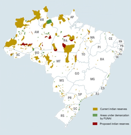
Figure One- This map shows the current indian reserves, areas under demarcation by FUNAI, and the proposed indian reserves in Brazil. The current indian reserves are in yellow, the areas under demarcation are in green, and the proposed indian reserves are in red. Many of the larger indian reserves are in northwest Brazil (Limongi, 2008).
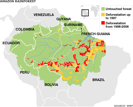
Figure Two- This map shows the deforestation of the Amazon Rainforest in Brazil. Green is the untouched forest, yellow is the deforestation up to 1997, and red is deforestation from 1998-2006. Like figure one, deforestation is mainly in northwest Brazil ("Deforestation Map").
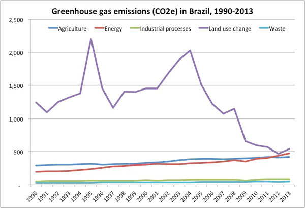
Figure Three- This graph shows the greenhouse gas emissions in Brazil between 1990 and 2013. Blue is emissions from agriculture, red is emissions from energy, green is emissions from industrial processes, purple is emissions from land use change, and blue is emissions from waste. Most of Brazil's greenhouse gas emissions are from land use change ("Rising Deforestation", 2014).
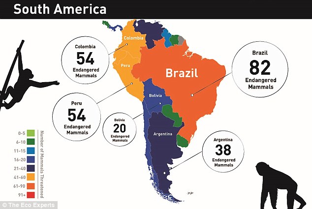
Figure Four- This map shows the number of endangered mammals in South America. Brazil has 82 endangered mammals. This is over one third more than other countries in South America (MailOnline, 2015).
|
References:
Brazil. (n.d.). Retrieved November 9, 2015, from http://www.brazil.org.za/environmental-issues.html
Brazil - Overview. (n.d.). Retrieved November 9, 2015, from https://www.cbd.int/countries/?country=br
Brazilian Indians. (n.d.). Retrieved November 9, 2015, from http://www.survivalinternational.org/tribes/brazilian
Deforestation Map. (n.d.). Retrieved November 9, 2015, from https://s-media-cache-ak0.pinimg.com/originals/9f/95/52/9f9552e4c873df3a162733bbd263ff3a.gif
Limongi. (2008, April 19). Indigenous Reserves in Brazil Map. Retrieved November 9, 2015, from https://en.wikipedia.org/wiki/Indigenous_peoples_in_Brazil#/media/File:Indigenous_brazil.jpg
MailOnline, V. (2015, April 13). Animals on the Brink of Extinction. Retrieved November 9, 2015, from http://www.dailymail.co.uk/sciencetech/article-3037027/Animals-brink-extinction-World-maps-reveal-countries-endangered-mammals.html
Rigby, C. (2015, April 23). Brazil. Retrieved November 9, 2015, from http://www.theguardian.com/world/2015/apr/23/brazils-indigenous-groups-battle-land-law-change
Rising Deforestation. (2014, November 23). Retrieved November 9, 2015, from
http://news.mongabay.com/2014/11/rising-deforestation-fossil-fuels-use-drive-brazils-emissions-8-higher/
